


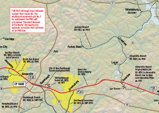
Railroads included in this map:
Norfolk Southern; CSX Transportation; Johnstown & Stony Creek; Ligonier Valley; Lehigh Valley Rail Management; Pennsylvania; Southwest Pennsylvania; Turtle Creek Industrial Railroad; Western Pennsylvania
This map originally appeared in the September 2014 issue of Trains Magazine.


The juxtspostion of the 1950 mainline vs. the 2014 version is stunning. Gone are the towers, stations, numerous branch lines and yard facilities. It shows how contemporary railroading has become “sanitized.”
Turtle Creek Industrial got pulled up, probably in the last year or so. The OOS branch in Jeanette is still in place.
Wow!! Must get this. Already I have a final explanation of the tunnel which must have been Radebaugh which I do remember seeing from the rear end of an Altoona excursion ca. 1959-60. Whoops! I have it in paper already (but some of the details seem new) but will now have a computer copy good only until the computer crashes.