


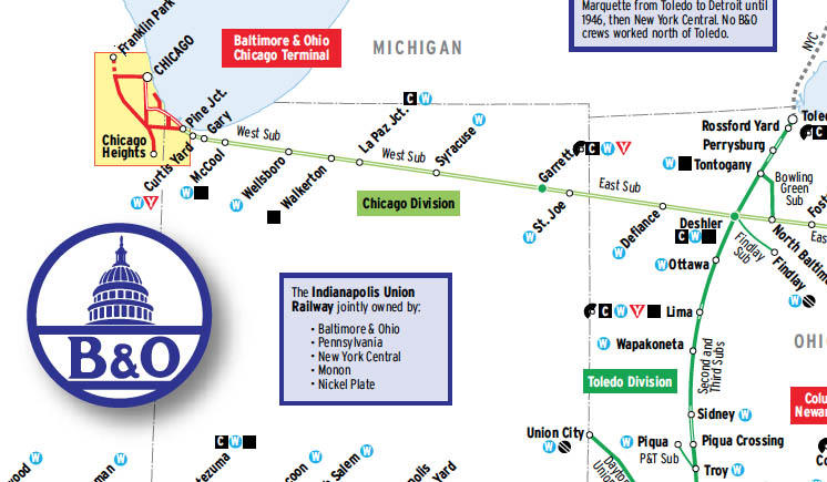
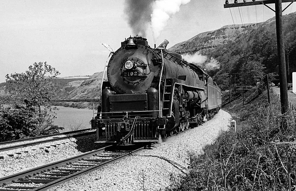
Here’s a rare chance to look at a Trains map before it appears in the magazine. This foldout map was originally scheduled to appear in the July issue, in time for the Baltimore & Ohio’s 190th anniversary, but as occasionally happens, outside forces intervened (in this case, short hospital stays for both the mapmaker and map editor). It now is slated to appear in the November 2018 issue. In the interim, here’s a chance to preview a map, which draws on information from employee timetables and maps from several contemporary sources, that shows the B&O’s divisions as of the early 1950s, as well as key locomotive service facilities and other details.
While we’ve had a number of B&O experts and enthusiasts review the map, we still welcome your comments if you find any details in need of correction before we finalize the version to appear in print.

I’d include Taylorville, IL, where the B&O crossed the Wabash as well as Pana, IL where it crossed the IC.
I greatly appreciate the B&O map and all the effort involved. I was a bit baffled by one thing, and that was the inclusion of Wylandville, between Pittsburgh, Pa. and Wheeling, W.Va. as if it was an important locale. Wylandville in the B&O’s 1954 Form 6 listing of stations, agents, etc. notes the population of 100 people and a 12 car siding.
Oh, Thank You! This is soooo sweet!
Thank you for a remarkable map. I see that there are two boxes noting the Buffalo and Susquehanna Railroad, but nothing on the more significant former Buffalo, Rochester and Pittsburg Railroad in the same region (Butler, PA to Buffalo, NY and Rochester, NY). The BR&P was a well constructed railroad in operation prior to being acquired by the B&O also in 1932.
B&O used Alton later GM&O yard and facilities in Springfield, IL.
As I recall, the last few miles into Shawneetown and Old Shawneetown, IL were jointly owned with L&N.
The Baltimore map does not show the Riverside roundhouse. It was between Camden Station and Locust Point on your map. Reading T-1 #2101 was overhauled here for the Freedom Train in 1975. The roundhouse is long gone but the MARC maintenance facility is now in the same area.
The map notes show the RF&P as owned by six railroads but does not show the Commonwealth of Virginia (actually Virginia Retirement System) share, which was about 20% of the total. In 1988 the RF&P became a holding company of the RF&P railroad and a RF&P real estate development company. When CSX wanted to take over the railroad, they and VRS eventually agreed that CSX would get the railroad and VRS would get the land company.
This document outlines the transaction:
https://ead.lib.virginia.edu/vivaxtf/view?docId=lva/vi00025.xml
I want to thank everyone for their comments — we’re just finishing a revised version of the map based on your notes.
Scott Marsh, Not only the tracks west of Belpre but also the tracks east of Parkersburg WV. Then to compound the stupidity, they took up the east-west line of the Central Ohio Sub. Compounded by the removal of the line between McConnelsville OH and Cambridge OH.
I grew up along the Midland Sub in Loveland ,Ohio. It`s a darn shame what has happened to that line since Chessie tore up the tracks from Greenfield, Oh to Parkersburg, WV. A mistake that has been reportedly lamented by CSX brass for years. The Indiana and Ohio runs maybe 4 trains a day on the Midland now, a far cry from 25 – 30 a day we used to see back in the 70`s and early 80`s. Sometimes the people running the show need to take a step back and re-think their decisions before they do something like this that can`t be undone!
Love these maps.And the history of them
In the late 1970’s and early ’80’s I recall listening to switching crews in the Chillicothe, OH area refer to the CH&D,a predecessor whose name stuck on until the very end. I moved from the area in 1990 and assume the tracks are long gone.
I noticed some errors and omissions on the Dayton to Cincinnati detail map:
– Missing from this map is the Wellston Subdivision main line through East Dayton, that connected with the North Dayton Cutoff at Tates Point, three miles east of downtown Dayton. East Dayton Yard was B&O’s primary yard in the Dayton area until Needmore Yard was expanded in 1969. There was a roundhouse and turntable at East Dayton, with coal, water and fuel oil facilities.
– Needmore Yard never had a roundhouse or turntable, but did have coal and water facilities for steam locomotives.
– B&O had trackage rights over the PRR for 15 miles from Miami City Junction to Dodson. The Dayton & Union Sub extended another 32 miles from Dodson to Union City, IN, not shown on the detail map.
– The map does show B&O’s Stillwater Branch between Miami City Jct and Stillwater Jct. This was a busy industrial serving line, but by the 1950’s B&O was operating only the eastern four miles, and was no longer going as far as Stillwater Jct. (Trains for the Dayton & Union Sub used the trackage rights over PRR, not the Stillwater Branch).
– The map does not show the Cincinnati Terminal Division, which had a separate employee timetable into the 1970’s. The CT Division encompassed 16 miles of track on the Cumberland-St Louis main line, between Oakley on the east side of Cincinnati, and CW Cabin along the Ohio River west of Cincinnati. It also included the southern 12 miles of the line between Cincinnati and Toledo, connecting with the First Sub at Glendale.
Third rail electrification was present on the SIRT branches until the mid-50s. The TRRA owners list shows ‘Rock Island’ while all other roads use long form names. The comment about 12 other roads is probably out of date by 1950 (I think the owner’s list may include some non-owners already).
On Chicago’s south side, the B&O/C&O passenger line utilized trackage rights on Rock Island’s Beverly suburban branch, roughly from Paulina Avenue to Racine Avenue along 89th Street. That short stretch is not indicated on the Chicago inset map.
On the B&OCT you should show the end of the Chicago Heights Branch being Faithorn which is 5.3 miles south of Chicago Heights. If you have space you might want to show Whiting as a junction of two lines.
In the Buffalo Division, Brookfield should be Brookland on the Wellsville SD. Also Addison SD extended further south-west of Galeton to Burrows (5.9 mi) Cincinnati area should show Glendale which was a division point with the Toledo Division. Tom Martin B&ORRHS
Gordon Schmidt – the B&OCT ends at Forest Park, but they had trackage rights over the CGW to Bellwood. I don’t know if those rights were used regularly.
Logan Geigner – IC via Brookdale was B&O’s original entry into Chicago in 1874. B&O initially used IC’s downtown station, then built their own near the current site of the Art Institute. These facilities were inadequate. The predecessors of the B&OCT were built in the 1880s and from that time, B&O made arrangements to use them. After a bankrupcy, the predecessor lines were reorganized and acquired by the B&O and renamed B&OCT. The line off the IC at 40th St was the Chicago Junction RR, originally part of Union Stock Yard & T
ransit Co.
Did the Pennsy have trackage rights on the B&O from Xenia to Union City, IN?
There is a note on the map that in 1950 the B&O marine fleet was divided between New York City and Baltimore. Does anyone know when the B&O stopped providing this service in Philadelphia?
Thank you.
Gordon, you are correct. That line is still maintained, but has not seen a train in perhaps two years. Canadian National stopped using it when they bought the EJ&E. Last I saw, there were stop signs for CN trains. It is insurance in case there is an outage on the EJ&E. B&OCT still has freight business delivering sugar cars to Ferrara Pan Candy Company south of the Eisenhower Xway in Forest Park.
In Chicago, at Brookdale, did the B&O have trackage rights in the IC up to about 43rd Street where the B&O The has a connection branch off and head west crossing Drexler to connect with the BOCT near Ashland?
In the Baltimore detail map the servicing facilities shown for Bay View Yard should actually be shown for Riverside, which is not shown but is to the left of Locust Point and to the right of Camden Station. Excellent map!
I was told that BOCT tracks ended at Madison St. in Forest Park. From Madison St. north was SOO Line. I worked at the Forest Park depot in the fall of 1959 as a SOO extra board operator. Occasionally a BOCT switcher would come as far out as the depot while switching, but no further.
Thanks.