


For photographers planning a trip to this rugged railroad, here are some basics for railfanning CN’s former BC Rail property.
Orientation
Remote. That’s the operative word to keep in mind while railfanning BC Rail. And the farther north you travel from Vancouver, British Columbia, the more remote things become.
Most of the territory the railroad traverses is wilderness, and in the event of an emergency, help can be a long way away. Prepare as you might for a camping trip: first aid kit; extra water, food and clothing; sturdy boots; and bug repellent are necessities.
Don’t let the higher latitude fool you either – take sunscreen in the summer months – and always remember you’re in bear country.
Despite sharing an identical language and many cultural interests, Canada is still a foreign country. Laws are different than in the U.S. – there is no Bill of Rights exactly like America’s, for example – so be aware of what’s allowed and what’s not.
I’ve never been approached by an authority in Canada while railfanning there, even in the post-9/11 world, but I don’t push the boundaries of propriety either.
Entering the dominion from Washington State is easier at Sumas, Wash. Canadian custom officials are just as strict here, but the line is shorter compared with Blaine, Wash., where Interstate 5 crosses the U.S.-Canadian border. If you have a passport, take it. The more identification you can provide, the less difficulty you’ll have. And don’t joke with customs officials on either side of the border. A glib remark such as “We’re here to shoot trains” won’t evoke a smile.
Okay, now that we’re through with that sober introduction, grab your camera, scanner, extra batteries for both, your favorite film and let’s railfan BC Rail.
Day trip
You can enjoy a good day’s outing just by staying between North Vancouver and Squamish, 40 miles up the line. Highway 99 parallels the main line, so access is fairly easy.
The main line between North Vancouver and Squamish skirts beautiful Howe Sound, and there are some spectacular photo locations. Make sure you take a telephoto lens along: Some locations will require a long-distance lens to fill the frame.
One thing to remember is that trains are infrequent. Daily manifests operate between North Vancouver and Prince George. Once you have a train, it’s best to stick with it and work ahead for shots.
Further in and further up
CN’s former BC Rail 461-mile main trunk between Vancouver and Prince George is divided into three subdivisions:
–Squamish Sub: North Vancouver-Lillooet, 156.2 miles
–Lillooet Sub: Lillooet-Williams Lake, 155.3 miles
–Prince George Sub: Williams Lake-Prince George, 149.5 miles
You won’t find many customers to switch between Squamish and Lillooet on the Squamish Sub, although the scenery is stunning.
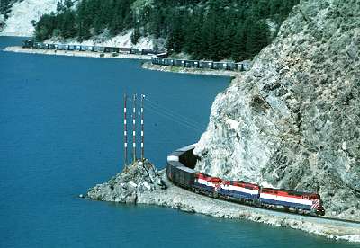
Farther north, you’ll encounter the line’s steep grade through Cheakamus Canyon, beyond which is the famed ski resort town of Whistler, mileage 73.7 (measured from Vancouver).
At Mt. Currie you can turn left and follow the road to Darcy, mileage 122.9, where dispatchers schedule several meets. “PB” pushers are also cut in at the north siding switch, and the track patrols clear here. The PB push cuts out at Mons, mileage 77.4.
Past Mt. Currie the highway veers to the right and doesn’t rejoin its course parallel to the railroad until you reach Lillooet.
About 20 miles north of Lillooet, Highway 99 veers to the right again and joins Highway 97. You won’t regain contact with the Lillooet Sub following the highway until you near Chasm. North of there, the highway keeps you near the main line almost all the way to Prince George.
If you’re adventurous, turn left on the Pavilion Mountain Road just past the horseshoe curve and overpass, then go straight up the side of the mountain and over the top to Kelly Lake. You can gain road access from here to the Moran (mileage 181.0) and Kelly Lake (192.6) sidings.
For the timid, turn south at Clinton, B.C., off Highway 97, follow the signs to Downing Provincial Park and the road will take you to Kelly Lake. You can get beautiful pictures here. The scenery abruptly changes to desert as the railway crosses the rim of the Fraser Canyon.
Williams Lake and Quesnel are also good places to catch meets. Both communitues have their original Pacific Great Eastern wooden depots. There is a nice park just north of the Quesnel station where you can take photos next to the river.
At Prince George, Canadian National’s main line between Jasper, Alberta and the port of Prince Rupert, B.C., crosses its BC Rail property.
Odell and beyond
Thirty miles north of Prince George is Odell, mileage 495.4, where the former BC Rail trunk begins to diverge into several branches.
At Odell, the Stuart Subdivision begins its west by northwest course to Fort St. James, 72.2 miles away. The line then continues northwest as the 200-mile Takla Subdivision, the former Dease Lake Line. If you like long strings of loaded log flatcars, this is the place for you. Log turns come off the Takla Sub almost daily. Remember that word, “remote”? The Takla Sub is located almost dead-center in British Columbia. Leave word with someone as to where you’re going and when you’ll return.
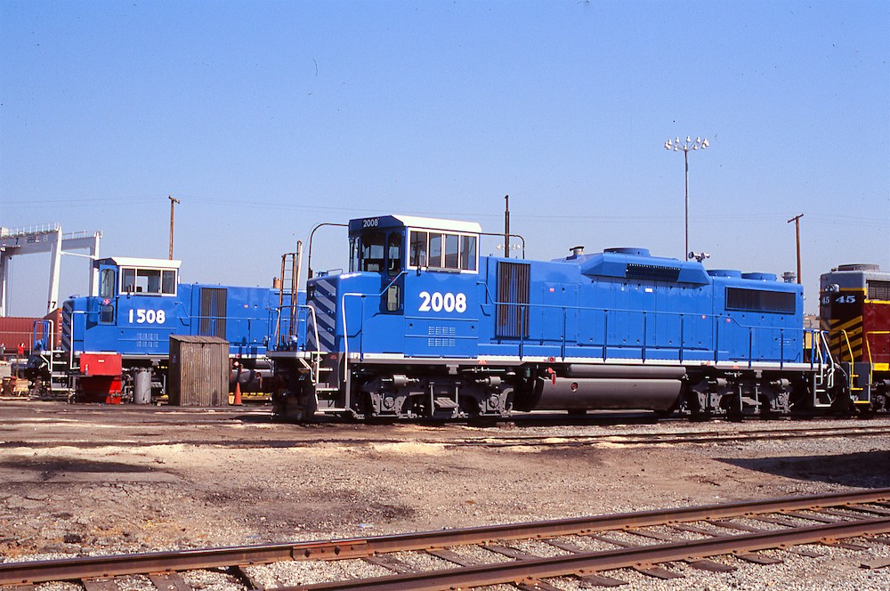
North of Odell is Wakely, mileage 537.2, where the 82.3-mile Tumbler Ridge Subdivision enters the main line. Coal trains lasted on the Tumbler Ridge Sub until 2003; even before then, the BC Rail EMD GF6C electric locomotives had been mothballed. Service is now provided by internal combustion EMDs and General Electric units.
End of the line
From Prince George, the main line continues north as the Chetwynd Sub to Chetwynd, 196.1 miles. Most trains run north in late afternoon and night, south in the early morning. The busiest stretch is from Prince George to Odell, mileage 495.4.
Departures out of Prince George include freights to Fort St. James, Mackenzie, and Chetwynd.
At Kennedy, mileage 567.3, follow the signs from the highway saying “Kennedy Siding”. Siding locations are marked out for taxi drivers sent out to retrieve crews that have gone dead on the law.
Near Azouzetta, mileage 591.6, the tracks run on opposite side of Azou Lake. You’ll find it easy to get in behind the Silver Sands resort, and the photos are spectacular.
Chetwynd, B.C., is the junction of the 60.9-mile Dawson Creek Subdivision, the most granger-like line on the former BC Rail. Highway 97 obliges the railfan by closely paralleling the Dawson Creek Sub, and good shots can be had at East Pine.
The Dawson Switcher works out of Chetwynd daily except Wednesday. The PGCH (Prince George-Chetwynd) turn is the day’s first arrival after switching Pinesul enroute. The SQJO (Squamish-Fort St. John) arrives at night, heading north to Fort St. John. Southbound trains to Prince George typically depart in the morning and afternoon.
From Chetwynd, the main line turns northeast as the Fort St. John Sub, 69.5 miles. North of Fort St. John, the main line finishes its run as the Fort Nelson Subdivision, a muskeg-laden, 250.8-mile-long line. By the time you reach Fort Nelson, you’re nearly 1,000 miles from Vancouver.
Access? Well, north of Chetwynd no highway parallels the main line. You’ll need a local map and time to plan ahead for shots.
During the summer, a thrice-weekly turn runs between Fort St. John and Fort Nelson. Train JN north to Fort St. John is called for 0800 Sunday-Tuesday-Thursday, while the southbound NJ arrives Fort Nelson Monday-Wednesday-Friday at about 2130.
If you’re truly adventurous and know how to handle yourself in frigid weather conditions, the turn runs six times a week during winter.
Worth the drive
Beautiful scenery, long trains, and the challenge of going where few railfans trod are the rewards for visiting BC Rail. Be prepared, though, and keep an eye for bears, which may be chasing railfans chasing trains.
BC Rail scanner frequencies:
Road channel 159.570/Repeater 161.370
Road channel 160.695/Repeater 161.520
Channel 3 priority yard 161.235
Channel 4 yard 160.395
Channel 7 yard 160.245
Channel 8 yard 160.815
Utility A 160.305
Utility B 160.560
Thanks to Dale Sanders and Adrian Telizyn for their invaluable assistance with this article.
In the April 2003 issue, TRAINS Magazine brings you the story of BC Rail, from its ambitious construction through a remote wilderness to the prospects for its future and what will be needed to keep the railway running.


Contrary to what you suggest, BC Rail was a viable and successful railway that did not need to be "rescued" by CN or anybody else. Most British Columbians were proud of it, and rightly so. It was sold to CN by a government that was ideologically committed to privatization, regardless of any rational argument. It has also been suggested that CN was deliberately given the inside track as the potential purchaser, although CP, and possibly BNSF were also interested.