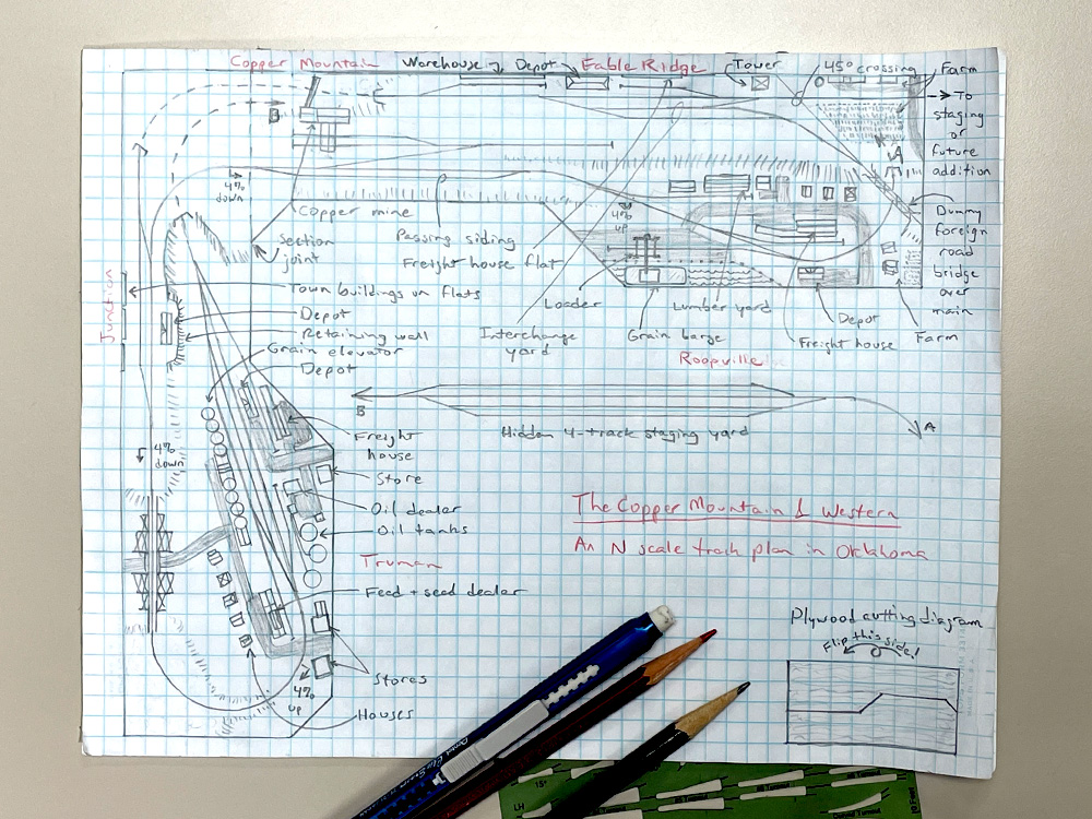
This started out as an attempt to draw a simple L shaped N scale track plan and came out one of the most involved sketches I’ve ever drawn. In August 2008’s Model Railroader I wrote an article called “Three track plans for one sheet of plywood.” (All three of those plans are available on Trains.com.) The idea was to explore what you could build on a train table made from a 4 x 8 sheet of plywood if you cut it up and rearranged the pieces. This time around I wanted to explore the same idea with an L shaped N scale track plan.
Although I drew a diagram showing how to cut the plywood into the two pieces needed to make this footprint, the idea of a flat tabletop didn’t last long. I wanted continuous operation, so I planned my plywood cuts to produce a tabletop with turnback “blobs” at both ends. But a simple dogbone schematic would mean either having two towns with a very short mainline run between them or putting one of the towns at the back of the layout. Flipping one end of the loop to form a figure-8 that crossed at the bend of the L let me situate both towns at the front of the layout with the maximum length of main line between them. That, of course, required a crossing, either at grade or grade separated. I scrapped the flat tabletop and went with a crossover, requiring cookie-cutter benchwork on risers to create the grades.
I’m a big fan of hidden staging. To make the figure-8 track plan look like a point-to-point, I hid the crossover and the end of one turnback loop in a tunnel and placed a four-track double-ended staging yard against the back of one leg of the L. Five feet of 4% grade yields only about 2½” of grade separation, which isn’t enough clearance for reaching in to fiddle the staging yard. You’ll have to plan operations to make staging self-reloading. Even so, you’ll want to leave an aisle along the back for access to staging just in case, rather than putting that side against a wall.
But putting that much of the return loop underneath the scenery meant that the town I later named Roopville would be the only thing going on at this end of the layout. What if I added a branch line above the hidden staging? A short passing/interchange track and a combination depot created the tiny dot on the map named Junction. A curve against the back of the bend led to another town, named Fable Ridge.
On many layouts I’ve seen, branch lines like this often lead either to a coal mine or a logging camp. Wanting to avoid those cliches, I made the primary business of the Fable Branch interchange with a nearby Class I, elevating the branch’s importance. The short two-track interchange yard, one for incoming cars and one for outgoing, can be fiddled between sessions or during, depending on how busy you want it to be. Spurs serving a freight house and a warehouse (or other industry, like a furniture factory) depicted as flats against the backdrop add more operating interest. I opted to emphasize that the line continues past Fable Ridge by running the track through a farm scene before ending it at the edge of the layout. But if more operation is a higher priority than scenery, you can change the crossing angle to reduce the size of the area on the far side of the Class I and lengthen the interchange and spur tracks. The track leading off the edge is an obvious place to attach a single-track staging cassette or, if you have the room, more scenicked layout.
I wanted a fairly long passing track somewhere on the layout between the towns. Since there wasn’t enough space between the curves in Roopville, I put it just to the left of there, so the local could use it for runarounds to switch the town.
Next came the town of Truman, which had plenty of straight track for a runaround of its own. I added another double-ended track parallel to it to serve a grain elevator, a landmark for an agricultural area like Oklahoma, which grows a lot of winter wheat. I extended this track for a stub to another granger mainstay, a feed and seed mill.
On the outside of the mainline, I added a couple more spurs to serve a freight house and an oil dealer. The latter could be a coal or LPG dealer if you prefer, depending on the era you’re modeling. I then sketched in some streets and filled the rest of the town with storefronts and houses. Behind the town, I figured that a wood trestle on the steep track up to Junction would make a good scene for dramatic trackside photography.
Next, I came to the town of Roopville. I found I didn’t have enough straight track between the curves on either side of town to insert the turnouts I needed. I shifted the depot from the straight track to the outside of the right-side curve and shortened the passing track to the left of town, which originally extended around the left-side curve a bit. This let me fit in one industrial spur on each side of the main, in addition to a house track between them.
For a typical small-town industry, I added a lumberyard to the inside spur. There was a lot of space on the outside of the main for my other industry, which left me with a lot of options. I decided to make it a riverfront wharf, where barges carrying grain, coal, or gravel could be loaded or unloaded. Though I labeled the vessel docked there as a grain barge, a modeler could build several different barges to be swapped out to suit the layout’s operational needs.
That left the empty section between the towns, next to the passing siding. I erased the track between Junction and Fable Ridge and redrew it as hidden track to give myself a blank canvas. I then went online to look up what mineral resources Oklahoma is known for. Coal, lead, and zinc are more prevalent, but I liked the sound of a copper mine, so I added one, reached by a short switchback. This gave the railroad both another source of outgoing loads and a name, the Copper Mountain & Western. Let me know if you were inspired by this L shaped N scale track plan.