Before the mega-merger movement of the 1980s, only a few U.S. Class I systems attained route-mileage in five figures. Santa Fe, Southern Pacific, and Milwaukee Road did so by spanning the transcontinental West, Pennsylvania and New York Central bulked up in the East, and Chicago & North Western and Burlington Route (if you include its Colorado and TExas subsidiaries) did so in granger country. Union Pacific didn’t quite make it, and Southern Railway barely did. Then Chessie System and Family Lines got there in the 1970s beginnings of today’s huge systems.
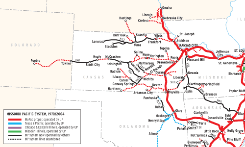
MIssouri Pacific is a genuine five-figure system that might not immediately come to mind. In 1970, when “MoPac” issued a roadmap-size” system folder on which this map is based, MoPac proper plus subsidiaries Texas & Pacific, Chicago & Eastern Illinois, and Missouri-Illinois comprised a system of about 11,2004 route-miles.
This map shows the MoPac of 1970 and the status of all those lines today. By glancing at the thicker, solid-color lines, one can see that most of the system’s main lines, except for the one to Colorado, survive as parts of Union Pacific, which absorbed MP in 1982 and formally merged it out of existence in 1997.
The area of origin for Missouri Pacific, the Show-Me State, has main lines that these days move a lot of Powder River Basin coal, plus intermodal traffic. For today’s Union Pacific, though, the “heart” of the old MoPac is truly Houston, where the hottest commodities are those in the lucrative “chemical coast” traffic. To understand fully how MP fits into UP today, one must mentally add the Katy, Cotton Belt, and Southern Pacific lines that UP absorbed.
St. Louis, where MoPac started, remained its headquarters city. The Pacific Railroad was chartered in 1851, opened the next year, and renamed Missouri Pacific in 1870. The system’s major components included St. Louis & Iron Mountain, from St. Louis south, chartered in 1851; International & Great Northern, in Texas (1873); and Gulf Coast Lines, a 1913 merger creation of a collection of roads between New Orleans and Brownsville, Texas.
Texas & Pacific, chartered in 1871 to build west from Marshall, Texas, was essentially taken over in the 1920s by MP, which by 1930 owned all T&P preferred stock and a majority of its common stock. MP fully merged T&P in 1976, by which time T&P had acquired the three “Muskogee Roads” centered around that Oklahoma town (Kansas, Oklahoma & Gulf; Midland Valley; Oklahoma city-Ada-Atoka).
MoPac bought into 113-year-old Chicago & Eastern Illinois in 1961; took control in 1967; sold (by ICC fiat) C&EI’s Evansville (Ind.) line to Louisville & Nashville in 1969; and merged C&EI in 1976. Missouri-Illinois, popularly the “Mike & Ike,” was a 172-mile pike acquired by MoPac in 1933. It operated in both states but crossed the Mississippi River on a ferry (until 1961), never a bridge.
Railroads included in this map:
Acadiana; Arkansas Midland; Blacklands; BNSF Railway; Border Pacific; Chicago & Eastern Illinois; Delta Southern; Fort Smith; Jacksonville, Gordonville & Delta; Kansas & Oklahoma; Kansas City Southern; Kyle; Missouri & Northern Arkansas; Missouri-Illinois; Missouri Pacific; New Orleans & Gulf Coast; Rio Valley Switching; South Kansas & Oklahoma; Texas & Pacific; Texas Northeastern; Texas-New Mexico; Union Pacific