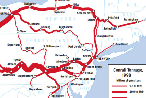
Twenty-four years separate these two density maps — a long time in North American railroading. The 1974 Penn Central map uses the last data available for the failed railroad; the 1998 Conrail map likewise is based on the last data before its system was split between CSX Transportation and Norfolk Southern. While similarities appear, the two maps show two entirely different traffic strategies for the same territory.
Conrail was created in 1976 from portions of six railroad properties: Penn Central; Erie Lackawanna; Reading; Lehigh Valley; Central of New Jersey; and Lehigh & Hudson River. It was at that time the largest railroad in the U.S., at 17,000 route-miles.
Conrail planners concluded that their predecessors had gotten into trouble on two counts. First, to compete with truckers for short-haul traffic they had to charge non-compensatory rates. Second, they had not eliminated thousands of miles of redundant or hopelessly useless trackage built to serve a disseminated traffic base that after World War II consolidated into a few locations. For instance, cities once had hundreds of coal dealers, each with rail service. That business now is represented by two or three power plants.
Not that Conrail’s predecessors had had much choice in the matter. Route rationalization through merger or abandonment was made very difficult under regulation, so predecessor managements had the Hobson’s Choice of hauling as much as possible — regardless of the rate — just for the cash flow, or ceasing business altogether. Deregulation in 1980 liberalized rate setting and line abandonment and sales. That, plus a sizeable injection of public cash to rebuild the rundown system, enabled Conrail’s planners to focus on traffic they knew could make them money: long-haul intermodal and merchandise traffic between Chicago and East Coast population centers.
The result was a 3,450-mile core made up mostly of former Penn Central lines. Note that most of the traffic is Chicago-East Coast; north-south traffic — which to Conrail was inherently short-haul — plays a minor role in the system. Much of what seems to be north-south, such as Selkirk-New York City, actually is east-west traffic turning a corner.
Railroads included in this map:
Central Railroad of New Jersey; Conrail; Erie Lackawanna; Penn Central; Reading