Railroads & Locomotives Maps Colorado’s scenic tourist lines

Colorado’s scenic tourist lines

By Angela Cotey | April 8, 2016

| Last updated on March 16, 2021

Your guide to some of the country’s most spectacular train rides and attractions

Email Newsletter

Get the newest photos, videos, stories, and more from Trains.com brands. Sign-up for email today!

ColoradoMoM

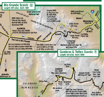
Railroads included in this map:
Manitou & Pike’s Peak; San Luis & Rio Grande; Denver & Rio Grande; Cumbres & Toltec Scenic; Leadville, Colorado & Southern; Durango & Silverton Narrow Gauge; Royal Gorge Route

This map originally appeared in the May 2013 issue of Trains Magazine.

Be sure to check out our Colorado Railroads special issue, available in April!

Success, start your free download!
Download the map PDF

One thought on “Colorado’s scenic tourist lines

  1. Leadville map has the Rio Grande branches into town confused. The farther north line that goes east-west is abandoned. The line that comes northeast from Malta is OOS, only becoming abandoned where the trail takes over the ROW into town.

You must login to submit a comment