Of all the scenic railroads in America, Colorado’s Georgetown Loop ranks near the top for the most audacious three miles of 3-foot-gauge track.
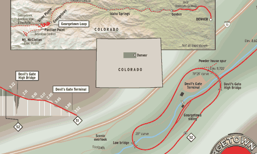
The words “twisty,” “curvy,” and “steep” do not even begin to do justice to this Lazarus-like railroad that was built in 1877, dismantled in 1938, and reconstructed in the 1970s and 1980s on the original Colorado Central grade west of Denver. This railroad uses two horseshoe curves to help gain some 500 feet on the climb between Georgetown and Silver Plume. And the signature, of course, is the full loop at the Devil’s Gate High Bridge.
Much has been made of the original high bridge and its magnificent 1984 reconstruction that spans the chasm 95 feet above fast-running Clear Creek. But in truth, the entire route is nothing short of a marvel — it’s like a breathtakingly detailed model railroad come to life.
For this, we have Union Pacific chief engineer Jacob Blickensderfer to thank. In a scramble to lay tracks from Georgetown to Leadville in a late-1870s quest for silver, he realized that a route laid straight up the narrow valley would result in an unacceptable 6 percent grade, while a series of loops would hold the grade to almost half that.
As the route profile at the right shows, builders faced a challenge when they came to the void at what is now known as Big Fill and the cut work just beyond. They moved tons of earth to construct the fill that is visible today from the overlook on eastbound Interstate 70. From the same spot, you also can pick out the zig-zagging grade of the abandoned Argentine Central, a connecting road that started in Silver Plume and ran to even higher elevations.
Blickensderfer’s rails never reached Leadville — the Denver & Rio Grande beat him to it. But between late May and early October, you can appreciate his efforts at building a railroad that climbs the Rockies from every available angle, looping its way up the Front Range.