


NEW YORK — The Metropolitan Transportation Authority has launched an initiative to protect Metro-North’s Hudson Line from climate change with work to address stormwater runoff, tidal flooding, and other issues.
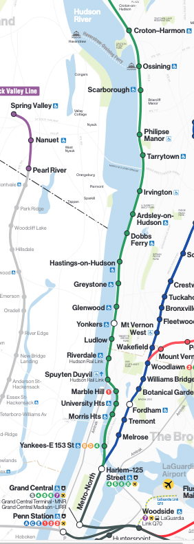
The Metro-North Hudson Line Climate Resilience Blueprint will focus on a 20-mile stretch of the 74-mile route between Croton-Harmon and Riverdale, rebuilding infrastructure such as culverts, drainage systems, retaining walls, and track.
“By the 2050s, 80% of the Hudson Line will be at increased risk of flooding due to rising sea levels and more frequent severe weather events,” Metro-North President Justin Vonashek said in a press release. “The Hudson Line is a key economic driver for the Hudson Valley and it’s important that we make these crucial investments to protect the future of not only the railroad, but the entire coastal area.”
The program will also outline design and other planning for future projects, addressing such areas as track elevations, performance criteria for drainage, and standards for shoreline improvements.
The MTA plans a series of Open House meetings on the Blueprint, with the first scheduled for April 23 at the Hastings-on-Hudson Library from 5:30 p.m. to 7 p.m. The Open House will feature a presentation from representatives of MTA Construction & Development, followed by a Q&A session.
“The Hudson Line Climate Resilience Blueprint will give us a clear path to make our service stronger and more reliable,” MTA Construction & Development President Jamie Torres-Springer said, “and we’re excited to share our vision with the commuters who depend on it.”
The Hudson Line — also used by Amtrak’s Empire Service — has suffered significant interruptions because of flooding in September 2021 as a result of Hurricane Ida [see “Metro-North Hudson Line service …,” Trains News Wire, Sept. 17, 2021]. The line was shut down again in July and October 2023 [see “Metro-North reopens Hudson Line …,” News Wire, July 11, 2023, and “Most Metro-North, Amtrak service to be restored …,” News Wire, Oct. 22, 2023.]
The project is an outgrowth of the MTA Climate Resilience Roadmap released in April 2024, and is part of the agency’s 2025-29 Capital Plan, which calls for a $68.4 billion investment in the MTA system.


Since there’s no article mention, other than the purple line map, of the NJ’s north end of the Pascack Valley line west of the Hudson River in upstate NY, I’ll repeat what I wrote about this the last time this topic came up.
The Pascack Valley Line, (PVL), formerly the NJ & NY RR, today ends at Spring Valley, NY’s Woodbine passenger yard. The PVL also connects with the remaining east end of the Piermont Branch whose remaining remenent runs from Spring Valley to Suffern, NY where there is yet another passenger train yard for the former E-L Rwy’s , now NJ Transit, mainline commuter train operations.
However, the east end of the Piermont Branch remanent between Monsey and Spring Valley has been embargoed due to a minor washout, whereas the active west end between Monsey and Suffern has some small branch line (NS) industry businesses such as a lumber yard.
All that said, why not repair that minor washout on the east end of the remaining Piermont Branch and reroute the Spring Valley commuter trains from the Woodbine Yard to the Suffern Commuter yard, and thereby picking up even more commuter business in the process through the towns of Ramapo, Tallman, Monsey,NY, and perhaps even Upper Saddle River, NJ. And that would eliminate the need for the Woodbine yard in Spring Valley.
The original Piermont Branch, that Daniel Webster rode back in the 1830s, was the original Erie RR mainline that used to run from Suffern, NY all the way east to the Hudson River cargo and passenger terminal near Nyack, NY where goods and people were transferred to NYC via river boats. A little later on, the Piermont Branch ran concurrently with the Pascack Valley Line, (NJ-NY-RR) in between Nanuet, NY and Spring Valley NY.
You mean the weather…
“An ounce of prevention is worth a pound of cure”.
The world could have avoided the worst extremes of carbon dioxide loading of the atmosphere if mitigation measures had been taken when the issue was identified long ago. But the drill-baby-drill crowd can’t recognize their short sightedness. Now, we pay the price.
“when the issue was identified long ago” There were no EV’s commercially available. Do you drive a GAS powered car? If an EV was it made with materials responsibly mined, smelted in mills run by renewable power, assembled in factories similarly powered. Few of us can meet that standard.
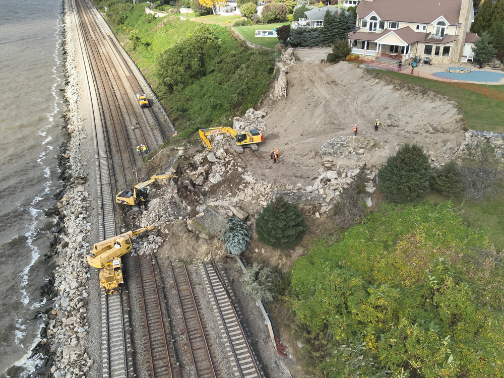
LOL. A local municipality allows zoning of residential and permits housing right up against the bluff overlooking a railroad. And you blame landslides on the weather.
Looking at the picture, I have to agree that landslide looks more to do with what you say that climate change! Is this the landslide that was caused by a leak in a swimming pool?
@ Steve Foster: Yes, the original house on the lot was torn down, a house twice as big with a pool was built in its place. The pool leaked and it caused a breakdown of the top of the bluff. So the homeowner built a retaining wall with yet more fill, with the pitch facing down to the house so as to direct surface water away from the bluff.
What the homeowner didn’t anticipate was the the fact the weight of all that stone and fill made it too top heavy and the bluff gave way.
One issue the home owner failed to do was hire an engineer to design the retaining wall. He went cheap and hired a landscaper instead. They simply terraced the bluff and placed stone and soil on top.
While I understand that the earth is warmer and there are more big rain events, I have to go along with your observations that this was a failure of humans to use care and common sense. I don’t know much about other such events on this line, but the picture tells a pretty clear story about this one.
Just a few miles east of where I live, the bluffs on the west shore of Lake Michigan have seen many similar incidents. The bluffs (generally about 100 feet high) are composed of layers of red clay interspersed with layers of water-bearing sand, sort of like a multi-layer cake with layers of very soft frosting between the cake layers. Add in fluctuating lake levels (normal cycles run over six feet historically between max. highs and lows.) Throw in some very strong northeast winds, ice chunks, etc. and it is no wonder that some big, heavy fancy houses placed near the edge didn’t stay there.
What evidence any of this has to do with climate change? As opposed to aging infrastructure that needs its normal cycle of maintenance or replacement.
Charles, University of Wisconsin at Madison runs a climate and weather class through Coursera. It’s FREE and very enlightening. There’s some other ones too at Cousera, the one through McHenry County College is very good as well.
“An investment in knowledge pays the best interest.” – Benjamin Franklin