If you want to know railroads, you’ve got to know Chicago. And Trains Magazine takes you there in its July 2003 Special Issue.
You’ll see how 500 freight trains a day thread their way through the city, check in at the 30 active interlocking towers, pay homage to the city’s six great passenger stations, and understand why Chicago’s role as the nation’s railroad capital will only grow larger in the years to come.
And if you want to see it all for yourself, here are Trains Magazine’s “10 Best” hot spots for Chicago train watching, first nominated by the magazine in its July 1993 all-Chicago special issue.
The criteria were fairly simple: Each location had to be accessible to the public, with good vantage points that would not require trespassing on railroad property. Accessibility via public transportation was desirable but not necessary (and all but three are). Each one had to feature a variety of railroads or styles of operation; and collectively, should include most of Chicago’s line-haul railroads. And each spot had to be busy. You’ll easily find others of your own, but the message is simple: Head for Chicago and enjoy the show!
Roosevelt Road
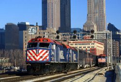
The best Chicago skyline views with trains are available from Roosevelt road (12th Street), which spans the multi-track routes of Burlington Northern Santa Fe, Amtrak, and Metra’s Rock Island District south of downtown.
Trains and yard moves keep action seemingly constant at this passenger-train only location. The Roosevelt Road bridge has ample sidewalk room, although it might be wise to be with at least one companion at what can be a conspicuous location. Roosevelt Road is a hearty walk from Union Station – go south along Canal Street. Parking is available on Canal Street, just off the viaduct to the west of the BNSF tracks.
Elmhurst
Anywhere on Union Pacific’s West Line — the former Chicago & North Western Overland Route for old-timers — can be a good spot. But locations west of Proviso Yard, UP’s hub, have more mainline freight action. One favorite is the pleasant suburb of Elmhurst, just west of Proviso. UP freights go slow here, either accelerating in departure or decelerating for arrival.
If you want more speed, other good spots include curves in Glen Ellyn and Wheaton; the EJ&E diamonds (with tower) in West Chicago, also known as Turner Junction and the end of a BNSF branch from Aurora; and the Fox River bridge in Geneva. Metra runs about 60 trains each weekday on the West Line.
The Elmhurst Metra station is at York Road in the city’s central business district. To drive to Elmhurst, exit from the Eisenhower Expressway (I-290) at St. Charles Road, go west to Poplar, then north to the tracks (just east of the depot). From the Tri-State Tollway (I-294), exit at North Avenue/Lake Street (Illinois 64/U.S. 20) and go west to York Road, then south to the tracks.
Rondout
Rondout, a storied junction 32 miles north of Union Station, offers variety on Canadian Pacific’s ex-Milwaukee Road main line to Wisconsin and the Twin Cities. An active interlocking tower guards the crossing of Elgin, Joliet & Eastern’s main line to Waukegan, and the divergence of Metra’s Milwaukee District North Line onto the Fox Lake branch.
Amtrak’s 14 Chicago-Milwaukee push-pull trains, plus the Chicago-Seattle Empire Builder, roar through Rondout, and Metra has 60 weekday Milwaukee North Line trains through the junction, although Rondout is no longer a Metra stop (Libertyville is the closest). CPR runs most of the freights through here; EJ&E fields a local, and Wisconsin & Southern comes off the Fox Lake branch nightly with a freight from Janesville, Wis., bound for Belt Railway’s Clearing Yard. One public vantage point is the old North Shore Line’s Mundelein branch bridge, now part of a trail, which spans the CPR.
Rondout is about halfway between Libertyville and Lake Bluff on Illinois 176. To reach Rondout from the northbound Tri-State (I-94), exit at 176 and go east.
Highlands
BNSF Railway’s former Burlington Route street-level, three-track “raceway” is Chicago’s busiest main line, when freight and passenger train volumes are combined. Just as with the UP West Line, anywhere on BNSF between Cicero and Eola yards can be a great train-watching location. This stretch encompasses 23 miles, from the Metra station at La Vergne to the yard at Eola, on the east side of Aurora. Perhaps the most serene spot is Highlands station in eastern Hinsdale. It features a park, a charming stone depot, and a narrow street “rainbow bridge.”
Metra fields 94 trains on weekdays, although only a handful stop at Highlands; most call at nearby Hinsdale. Amtrak’s Southwest Chief, plus the California and Illinois Zephyrs also ply the route.
Among other raceway favorite raceway vantage points: La Vergne, in Berwyn, the west throat of BNSF’s Cicero Yard and where the Canadian National’s Freeport Sub bridges the BNSF main line; Riverside, site of a picturesque city water tower and depot; La Grange Road, not far from where the Indiana Harbor Belt ducks under BNSF; and Lisle and Naperville, towns at each end of a long S-curve.
To reach Highlands, exit the Tri-State (I-294) at Ogden Avenue (U.S. 34), go west to York Road, then south to Chicago Avenue (47th Street) just across the tracks, then east to the park. If you’re going by auto, Ogden Avenue generally follows the BN through the suburbs.
Joliet
Trains of seven railroads can be seen from the platforms of Joliet Union Station, 40 miles from Chicago. The building, refurbished in the early 1990s, is above street level at the southeast corner of downtown in this industrial city of 77,000. It is the terminus for Metra Rock Island District trains (46 on weekdays) and Heritage Corridor trains (three each weekday rush hour), and it serves Amtrak’s six daily trains on the route to Springfield, Ill., and St. Louis.
As with half of our Chicago Hot Spots, diamonds are a train-watcher’s best friend at Joliet. But only one Rock Island track is left to cross the four that split the depot and the interlocking tower, which is still in use. BNSF’s busy former Santa Fe main line to Kansas City claims two of the four east-west tracks. Union Pacific trains to St. Louis use the other two, as do occasional Canadian National coal trains bound for the nearby Plaines Power Station. UP track ownership changes to CN a few blocks north of the depot, but a CN switch job goes through the junction. On the Rock Island, CSX runs two weekday freights, usually at night; Iowa Interstate sends two through daily, east in the early morning, west in the afternoon.
Elgin, Joliet & Eastern’s yard and back shop are a mile or so northeast of Union Station; the J’s main line passes over the BNSF and CN north of town and crosses Metra at grade a mile east of union Station. A view of the J yard is available from the overpass on Jefferson Street, U.S. 7.
To reach Joliet Union Station from I-80, exit at either Illinois 53 (Chicago Street) or Richard Street and go north until you pass under the Rock Island.
Homewood
Homewood is a south suburb at the north end of a stretch that offers the best Chicagoland viewing of Canadian National’s former Illinois Central main line. Through the city and close-in suburbs, the CN main is elevated above street level. At Homewood, it comes down to grade level except for street underpasses and the EJ&E railroad underpass at Matteson. So, anywhere from Homewood station south six miles to University Park, where the Metra Electric line ends, is about equal. Metra Electric, formerly IC’s operation, runs on the westernmost two tracks of CN’s multi-track right of way.
Homewood is also at the south throat of Markham Yard, no longer CN’s primary freight facility (that’s now Glenn Yard in southwestern Chicago) but still very much in use, with the Gateway Intermodal Terminal occupying land once used for carload switching.
Markham is also the site of CN’s large Woodcrest diesel shop. Homewood is a Metra Electric stop, and is Amtrak’s suburban stop for the Illini and City of New Orleans. Norfolk Southern runs three or four trains a day on trackage rights to Decatur, Ill. Metra Electric runs hourly off-peak service Monday through Saturday, and every two hours on Sundays.
The Tri-State Tollway (I294 and I-80) passes over Markham Yard. To reach Homewood from the west, exit the Tri-State at Dixie Highway. Go south until you pass under the IC, then turn right to the depot. From the east, exit the Tri-State at Halsted Street, Illinois Route 1. Go south a mile to Ridge Road, then west two miles through the Homewood business district to the tracks.
Blue Island
The junction that offers the biggest variety of freights at any single Chicagoland site, and one of the busiest, is “Blue Island crossing,” one of two Hot Spots in Blue Island, a gritty southwestern suburb of 21,000. The other is Vermont Street, one of two Metra passenger depots.
CSX’s B&OCT main line from Pine Junction, Ind., splits here, with one leg headed north to Chicago and the other leg, jointly owned with Indiana Harbor Belt, running northwest around the city. Slicing across is Canadian National’s former Grand Trunk Western main line. All cross Broadway at grade, protected by the watchman’s tower. Also visible are two of the five imposing truss bridges over the Calumet Sag Channel Canal, which add a ruggedly photogenic element to many pictures. The interlocking tower is out of sight across the canal to the north.
Trains from at least 8 railroads pass through this junction. Metra’s Rock Island District crosses overhead near the diamonds. An interchange ramp track is used by Iowa Interstate and CSX trains off the Rock Island to reach their yards. Chicago Rail Link occasionally sends a local out to the Rock.
Vermont Street is parallel to Broadway but north of the Sag Channel. The two Metra depots – across the tracks from one another – are a half-mile northeast of Blue Island crossing (but a longer and indirect walk). The Rock Island District depot is at the divergence of the Suburban Line from the Main Line. Nearby is the tiny, two-track outer terminus of the Metra Electric’s Blue Island branch. Besides all the Metra trains (there is no Sunday service on the Electric here), freights of Iowa Interstate and Chicago Rail Link, a switching line with freight rights on most of the former RI track in Chicago, go through here.
To reach Blue Island, use the 127th Street exits from either the Tri-State Tollway (I-294) to the west (the exit is marked for Cicero Avenue, Illinois 50), or I-57 to the east. Go to Western Avenue, then south to Vermont Street; Western Avenue’s connection with Broadway is via street ramps, as Western passes over Broadway as well as the Rock Island District on the same overpass.
Dolton
Dolton (pronounced Dahl-ton), five miles east of Blue Island, is the most interesting junction in the southeast suburbs. It is where the IHB and B&OCT (CSX) double-track main lines cross Union Pacific’s north-south double-track main. A half mile west of Dolton, the B&OCT and IHB routes pass under the elevated Canadian National (ex-Illinois Central) main.
On an average day, Dolton sees more than 40 freights from five railroads: IHB, CSX, UP, CN, and CPR. East of Dolton, IHB and B&OCT parallel each other for a mile before separating for State Line and Hohman Avenue junctions, respectively.
Dolton’s tower, south of the IHB, is aligned along the former Pennsylvania “Panhandle” line, now abandoned. CSX trains coming up on UP’s ex-C&EI main from the south leave the UP at Dolton to access Barr yard. These include the few trains off the Monon, which run on CN and UP via Thornton Junction, a crossing 3.4 miles south of Dolton. Some CN run-through trains also go this way.
CPR trains through Dolton include the 500-series, which operate on CSX to Detroit and Canada, as well as those going south on CSX to southern Indiana.
From the Metra Electric Riverdale station at 138th Street, a moderate walk of less than a mile through a residential area east on 138th, then southeast on Lincoln, brings you to the junction. To reach Dolton by car from the Calumet Expressway (I-94), exit on Dolton Avenue west to Lincoln, then northwest to the IHB grade crossing.
Porter
Perhaps the most pastoral yet busiest spot in Indiana’s portion of Chicagoland is Porter, a junction dominated by Norfolk Southern and Amtrak. Porter is a small town of 3000 next to the larger community of Chesterton. The junction, 40.6 miles from Chicago Union Station, is where Amtrak’s Michigan Line passenger route splits from Norfolk Southern’s main line, the former New York Central, to Elkhart Yard and points east. At the same point, which used to have diamond crossing, CSX’s ex-Conrail freight branch off the Indiana Harbor Belt from Blue Island converges. This branch and the Amtrak Line comprised the original Michigan Central route to Detroit.
The junction has been remotely controlled since March 1985, after which PO (Porter) Tower was razed. Now it’s just “CP 482,” for “controlled point” and the milepost from Buffalo, N.Y.
Just east of the Amtrak switch, in the same junction, CSX’s former Chesapeake & Ohio route to Grand Rapids also diverges. Trains of CSX and Canadian Pacific, plus Amtrak’s Chicago-Grand Rapids Pere Marquette, use this line to the east and NS’s main line to the west.
Amtrak runs 12 trains a day through Porter. Most are on the Michigan line: three Detroit/Pontiac trains each way plus the Blue Water for Port Huron. The overnight Lake Shore Limited and Capitol Limited use NS’s main line.
The junction is just south of Interstate 94. Exit Indiana 49 south, go into Chesterton, and just beyond the Conrail tracks, take Broadway west into Porter to 18th Street, then north to the tracks.
Hammond
Three separate locations, each a busy Hot Spot in its own right, are in Hammond, Ind., a blue-collar city of 85,000. They are the Amtrak depot and two junctions with towers, State Line and Hohman Avenue.
The Amtrak station “Hammond-Whiting,” in Hammond’s Robertsdale neighborhood on Conrail’s main line at the lakeshore, sees 14 Amtrak and more than 40 Norfolk Southern trains a day. An EJ&E branch runs parallel to CR north of the depot. It’s seldom used by its owner, but you’ll see the switchers of little South Chicago & Indiana Harbor (former Chicago Short Line) on it. The Amtraks are the same as at Porter (18 miles to the east), with the addition of the Three Rivers. To reach the depot from the Indiana Toll Road or Calumet Skyway (I-90), at the state line, exit on eastbound Indianapolis Boulevard, U.S. 12-20-45. Go to Calumet Avenue, then north to the tracks. A day at Hammond-Whiting was featured in September 1985 TRAINS.
Four miles south of the Amtrak depot on Hohman Avenue is South Shore Line’s Hammond passenger station. (Go south on Calumet, U.S. 41, to Gostlin Avenue, then west a half mile.)
Another three blocks west of the depot, via Gostlin, Dearborn, and Brunswick streets is State Line Tower, hard by the Illinois border. Where once you could see Erie Lackawanna, Monon, Chesapeake & Ohio, and Wabash, as well as predecessors of today’s occupants, now only two main lines cross: CSX’s ex-Baltimore & Ohio to Garrett, Ind., and points east, and Norfolk Southern’s ex-Nickel Plate line to Fort Wayne and beyond.
The South Shore is a city block north of the tower, and that line, NS, and CSX each are crossed by a north-south Indiana Harbor Belt branch used about five times a day. CPR haulage trains and the occasional EJ&E switch job run on CSX. South Shore schedules about 40 passenger trains each weekday, and has a few diesel-powered freights.
To get to State Line from the east, use the Calumet Avenue (U.S. 41) exit on the Indiana toll road, I-90. From the west, off the Calumet Expressway (I-94), exit at 130th Street east to Burnham Avenue, then go southeast along the South Shore past the Hegewisch depot to the state line.
South of State Line Tower a mile along the Norfolk Southern is Hammond’s third Hot Spot, Hohman Avenue Tower, just north of the downtown district. Here, with diamonds in a street intersection that’s guarded by gates controlled manually from the interlocking tower, NS crosses the old Michigan Central route, used by IHB and CSX freights to or from Blue Island (Ill.) yard.
Ten alternate Chicago hot spots…
So, we cheated – we’ve given you more than 10 top hot spots. Add the extra one in Blue Island to Hammond’s three, and you get 13. Actually, we’ve mentioned dozens if you’re liberal on the CN&W and BN routes. Enjoy all of them, and more, in the Railroad Capital.
And before you stroke that keyboard to tell us of your favorite Chicago train-watching spot that wasn’t included in our “Top 10,” allow us to mention our “Second 10.” Some lack the easy public accessibility that we made a requirement for the “first team.” From north to south:
Deval Tower, Des Plaines: The active interlocking tower (Deval is short for Des Plaines Valley) sits amid three sets of diamonds where UP’s Northwest Line, UP’s freight cutoff for Wisconsin trains, and CN’s Wisconsin Central all cross.
Tower B-12, Franklin Park: Controls the crossing of CN with Metra’s Milwaukee West Line, also a route for CPR through freights to and from Milwaukee. The junction marks the north end of Indiana Harbor Belt, and you’ll see transfers of several roads, including BRC and CN.
River Forest: A station on UP’s West Line, just west of CN’s ex-WC bridge, which crosses over UP. UP intermodal trains and transfers of several roads can be seen.
Tower A-2, Western Avenue: A good Metra spot. The Milwaukee District crosses the UP West Line, and it’s at the eastern throat of both Metra coachyards, California Avenue (UP) and Western Avenue (MILW). Amtrak’s Chicago-Milwaukee trains pass through here, too. We chose this spot for Metra rather than Mayfair Tower, six miles north, where the Milwaukee North and UP Northwest lines cross, because Mayfair is not as accessible for visitors. At A-2, the Milwaukee Western Avenue station platform is handy.
Twenty-First Street: The southerly of Amtrak’s towers near Union Station, is where Amtrak’s routes to Joliet and the East Coast divide. Canadian National’s freight link crosses here. The tower is just south of Amtrak’s tall Chicago River lift bridge, itself an engineering landmark. Every Amtrak Chicago headed east of Chicago crosses the bridge, as do Metra Heritage commuter trains, and NS and UP freights. In the mornings, you can watch the action from a city park along the Chicago River, sandwiched between the Amtrak lift bridge and the CN tracks.
Panhandle Crossing, or Brighton Park: A noninterlocked junction where CN’s Joliet line (Metra Heritage) crosses two parallel north-south lines, B&OCT (CSX) and NS. Transfers of many railroads go through here; a cabin with semaphores guards the crossing.
Lemont: In this Chicago suburb, BNSF’s ex-Santa Fe main line crosses the Sag Channel on a sharp S-curve. The track is very close to CN’s Joliet route, also used by UP road freights. The restored stone depots in Lemont and nearby Lockport, the oldest in use by Metra, were built in 1853 and 1863, respectively, by Chicago & Alton.
Thornton Junction: Located in the south suburb of South Holland, the crossing of CN’s ex-GTW main and the joint UP-CSX line, also used by CPR’s Indiana freights. The tower has been razed.
Fort Wayne Crossing: West of Valparaiso off Indiana 130 is the diamond of CN (Grand Trunk Western) and NS (Nickel Plate). Parallel to NS is CSX’s old PRR main line, once the route of the Broadway Limited. The junction is named for PRR predecessor Pittsburgh, Fort Wayne & Chicago.
Pick up the July 2003 Special Issue of TRAINS Magazine – your complete guide to the railroads of Chicago!