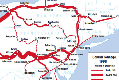
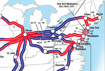
Twenty-four years separate these two density maps — a long time in North American railroading. The 1974 Penn Central map uses the last data available for the failed railroad; the 1998 Conrail map likewise is based on the last data before its system was split between CSX Transportation and Norfolk Southern. While similarities appear, the […]
Read More…
An English import, the American railway diverged sharply from English ideals. Environment proved stronger than genetics — settled and industrializing England constrained railway builders to design the most efficient routes possible, whereas their counterparts in unsettled and impecunious America disregarded gradient and circuity on pain of not completing lines at all. As the American era […]
Read More…
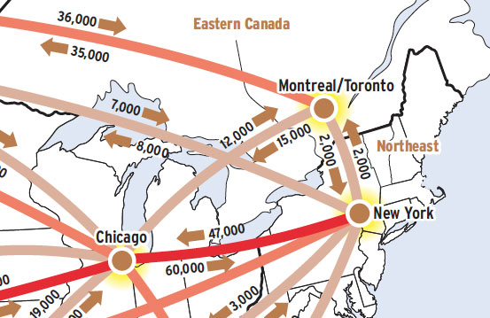
This Map of the Month was featured in the August 2004 issue of Trains magazine. This map shows a commodity flow, or what everyone treats as a commodity flow: the trailers and containers that move in intermodal lanes in the U.S. and Canada. These boxes might actually contain anything from hay to helicopter parts, but almost […]
Read More…
This Map of the Month was featured in the March 2007 issue of Trains magazine. Imagine if you were to go back in time and tell Cornelius Vanderbilt that the giant railroad system he had methodically assembled — the powerful New York Central — would one day be carved up by two coal roads from […]
Read More…
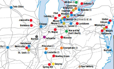
In the early 2000s, North America’s 88 automobile assembly plants produced about 15 million new cars and trucks a year. And railroads moved 70 percent of the vehicles built in the United States alone. Most Canadian and U.S. plants are concentrated in a wide corridor stretching from Toronto to Mobile, Ala. Plants in Mexico are […]
Read More…
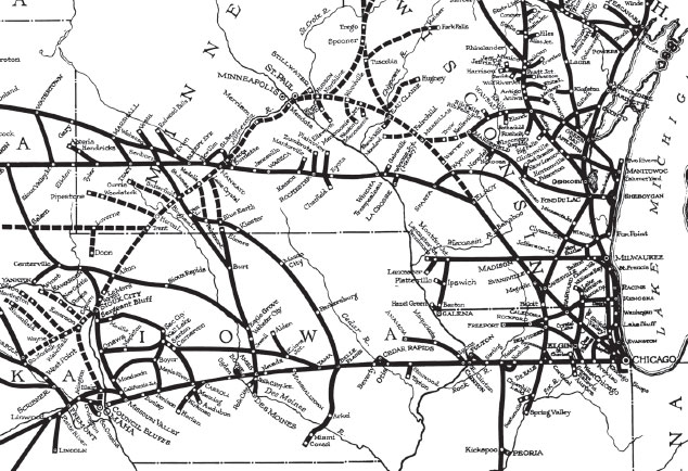
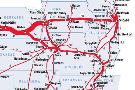
This Map of the Month was featured in the August 2002 issue of Trains magazine. If ever two railroads practiced seamless service decades before it became a railroad industry buzzword, it would be the Chicago & North Western and the Omaha Road. The Omaha Road, the usual shorthand for the Chicago, St. Paul, Minneapolis & […]
Read More…
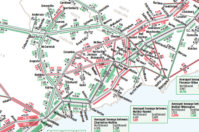
This Map of the Month appeared in the February 2005 issue of Trains magazine. Say good-bye to two successful railroads,” was the startling way Seaboard Coast Line introduced itself in magazine advertisements in summer 1967. Below the picture of two streamlined diesels blurring nose-to-nose into each other, the ad continued with a gushing declaration: “The new […]
Read More…
This Map of the Month was featured in the November 2003 issue of Trains magazine. Amtrak advertisements showcase images of passengers looking out windows at breathtaking scenery, and gleaming trains winding through spectacular canyons or along scenic river- banks. But that’s only half the story. Long-distance trains (those on routes of 750 miles or more) […]
Read More…
This Map of the Month was featured in the November 2001 issue of Trains magazine. Train frequency per 24 hours on the vast Union Pacific system, in first quarter 2001, is revealing both for what is indicated and what is not. Consider, if you will, the pre-1982 Union Pacific, i.e., before merger mania. With just […]
Read More…
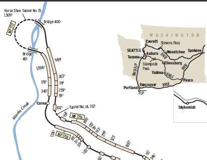
This Map of the Month appeared in the December 2005 issue of Trains magazine. Among the many hazards of running trains at high elevations in North America are the difficulties of snow, ice, and avalanche. This was well illustrated in Washington state where the Great Northern crossed the Cascades at Stevens Pass, named for John F. […]
Read More…
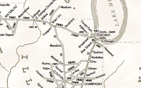
This Map of the Month appeared in the October 2007 issue of Trains magazine. Like other great American railroads, the Illinois Central was a melting pot of many smaller lines — some acquired through lease or purchase, others set up by IC to construct new routes. This map charts the 88 different names that made up […]
Read More…
This Map of the Month appeared in the August 2003 issue of Trains magazine. Where does a railroad go? Might seem like the most basic of questions. But with trackage rights and service alliances, a railroad’s franchise — its sphere of influence — may extend far beyond the outermost mile of track it owns. […]
Read More…
