Model railroaders have long relied on historic maps for information about track arrangements, trackside industries, and building footprints. With the continual growth of the internet, finding these railroad maps online is becoming easier all the time.
Here are some helpful sources for finding both current and historic railroad maps online.
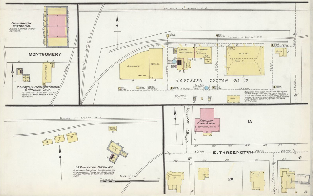
Sanborn Fire Insurance maps
Sanborn Fire Insurance maps, which show detailed arrangements of city streets, structures, and track arrangements dating back more than 100 years, have long been a valued source of prototype information for model railroaders. Not only do these maps show where things were way back when, but also information about the buildings shown. Color codes denote the basic construction of the structures (brick, metal, or wood frame), commercial buildings are labeled with their business names, and individual parts of larger structures are sometimes designated, too (warehouse, shipping, boiler room, or machine shop, for instance). This kind of information is invaluable for the modeler who needs to know what kind of freight cars might get spotted where along an industrial spur.
An archive of more than 35,000 Sanborn maps is available free to view and download from the Library of Congress website, https://www.loc.gov/collections/sanborn-maps/. Almost no location is too small to have been recorded in these maps.
Railroad Maps Collection, 1828-1900
If you model the early steam era, the Library of Congress has another archive of railroad maps online. This collection catalogs railroad maps prior to the turn of the previous century. Most of the 635 maps in this collection show entire railroad systems, rather than detailed city views. Nonetheless, they are great for viewing overall routes and finding out what towns were served, giving you an idea of what Sanborn maps to look for to fill in the details.
Since they are free to view and download in high-resolution TIFF format, they’re good not only for research. You can also have them printed out and framed to decorate the walls of your train room or crew lounge. https://www.loc.gov/collections/railroad-maps-1828-to-1900/
Historic Map Works
This company claims to have 1.6 million vintage maps and other images available for browsing and purchase. I’m not going to check their math, but a quick browse shows they do have a whole lot. The collection is rather scattershot; while there are a lot of great, detailed maps from different time periods for mid-sized and larger cities, the chance that they have a map for your locale and your time period isn’t guaranteed. And not all of their maps show railroads, though the older the map, the more likely it does.
Their catalog is free to browse, and you can zoom in for great detail. Historic Map Works is a business, though, so you can’t download or easily screen-shot their maps without paying. But if you find they have just the map you need, buying a print is probably worth the investment. http://www.historicmapworks.com/
See Trains Magazine’s collection of Maps of the Month, online.
Open Railway Map
From olden days to the modern day, we turn to OpenRailwayMap.org. This crowdsourced effort, based on data from OpenStreetMap, seeks to map every inch of railway in the world. The result is stunningly complete and detailed, even mapping out rail yards in places as remote and inaccessible as Syria and North Korea. (For the most part the map lines stop at the borders of Afghanistan, but it seems that so do the rails.) But if you’re looking for something like the track arrangements in Kansas City Southern’s East St. Louis Yard, you can find it here, superimposed on an easy-to-read, detailed grayscale map. (Color is available, but adds more detail a railroader probably doesn’t need).
Major structures are identified by name on the map. There are even options to view the tracks’ maximum speeds, signaling, electrification, and gauge! Only the option to superimpose tracks on satellite photos could improve this resource, but in the meantime, you can just load Google Maps in another browser tab and flip back and forth. https://www.openrailwaymap.org/