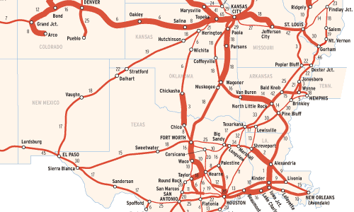
This map reflects an average day for the Union Pacific Railroad in late 2003. Trains per line per day is indicated above each major line segment except where data is not available. These numbers have changed little since our previous UP trains-per-day map in the November 2001 issue, except for the Sunset Route between West Colton, Calif., and El Paso, Texas.
Traffic-density maps typically show gross ton-miles averaged over a year, rather than the number of trains that run on average day. (Most Class Is still do not prepare the latter on a regular, system wide basis.) In the regulated era before 1980, trains-per-day maps were rare. Traffic patterns evolved slowly and railroads were small enough that everyone knew the patterns and the trends. Traffic varied seasonally, depending on whether a line was dominated by harvest moving to market in the fall, heating coal moving to cities in the winter, or lumber moving for the summer construction season and fall perishables packing season.
Trains-per-day maps today are useful for planners and confirm what a chief dispatcher already knows, but don’t readily indicate the type of train: a light helper running downhill after helping a 17,500-ton coal train to the top of the grade counts the same as the train it just helped. When tonnage and train counts are considered together, as they are on this map, some nature of the type of train appears. Lines with very light tonnages surrounded by lines with heavy tonnages indicates the presence of light helpers, such as Beaumont to West Colton, Calif.; or empty moves only, such as Hiawatha to Marysville, Kans., where traffic is predominately empty coal trains returning from the Kansas City gateway to Wyoming’s Powder River Basin. Heavy tonnage lines show the presence of bulk moves in both directions, or a highly advantageous load-empty ratio. The latter is characteristic of the Chemical Coast of Louisiana and Texas, where intermediate feedstocks move between petrochemical plants and product flows outward.
Line segments showing 5,000 to 6,999-ton trains might seem unimpressive, but it’s worth recalling that in the steam era any line that regularly ran trains of more than 5,000 tons was unusual.
Railroad included in this map:
Union Pacific