


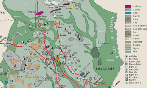
This map of the Kansas City Southern and Louisiana & Arkansas (just prior to their 1939 operational merger) is based on a document undoubtedly produced by the KCS traffic department to show shippers the abundance of natural resources within the roads’ territory.
KCS founder Arthur Stilwell had left his secure position with a Hartford insurance company in the 1880s for a more adventuresome life as a railroad builder in Kansas City. Under the name Kansas City, Nevada & Fort Smith, Stilwell built south toward bituminous coal deposits near Pittsburg, Kan., and beyond to lead and zinc mines around Joplin and Neosho, Mo. By the time the rails reached Sulphur Springs, Ark., they carried a new name: Kansas City, Pittsburg & Gulf, indicating clearly that Stilwell’s goal was the sea [see “The Haywire Becomes a Livewire,” October 2006 Trains].
His push south was motivated by the vast regions of virgin forest in the Ouachita Mountains that began south of Heavener, Okla., and stretched in various forms all the way to Louisiana and Texas. But financial problems on this section were severe. With American capital drying up in the late 1890s, Stilwell played one of his famous hunches, and sailed to Holland to sell $3 million in bonds (hence the use of Dutch family names for many towns and sidings, a few of which are on the map). The KCP&G’s final spike was tapped down in 1897, and the line immediately began to be a grain-hauling moneymaker.
Stilwell’s lucky streak ended a few years later when the line emerged from bankruptcy as the Kansas City Southern, with no involvement of its builder. However, that Gulf Coast geology ultimately laid a golden egg: In 1901, the Lucas oil gusher at the Spindletop field north of Beaumont ushered in the first Texas oil boom. And marrying L&A with KCS enabled the system to tap the eastern Louisiana petrochemical region around Baton Rouge.
Railroads included in this map:
Kansas City Southern; Louisiana & Arkansas


How many other north american railroads list “diamonds” on their mineral resource maps?