This Map of the Month appeared in the November 2004 issue of Trains magazine.
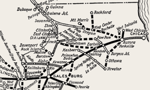
“Everywhere West” was an appropriate slogan for a railroad that once operated over 12,000 route-miles across America’s heartland. The classically styled 1940 official railroad map at right shows how the Chicago, Burlington & Quincy grew from modest beginnings to become a major Western system.
The Burlington’s roots date back to 1850 and the Aurora Branch Railroad, a 12-mile line that extended from Aurora, Ill., just west of Chicago, north to Turner Junction (now West Chicago) and a connection with Chicago’s first railroad, the Galena & Chicago Union (later part of Chicago & North Western). By 1852, the future Burlington line had expanded 45 miles west from Aurora to Mendota, and its name was changed to Chicago & Aurora. The railroad continued its westward growth, reaching Galesburg in 1854 and the Mississippi River across from Burlington, Iowa, in 1855, which was the year it took the name Chicago, Burlington & Quincy.
In 1864, the CB&Q built its own line into Chicago from Aurora, bypassing its old G&CU connection at Turner Junction. The move turned the system’s original 12-mile segment into a branch (most of which still has service in 2004), but more important, gave the Burlington a direct route into Chicago, which would quickly become a vital link.
“The Burlington Route,” as it became known, continued building westward across the plains, reaching Lincoln, Neb., in 1870 and Denver in 1882. Meanwhile, a subsidiary, Chicago, Burlington & Northern, built northward from Aurora to, and then along, the Mississippi River to St. Paul and Minneapolis. This route was completed in 1886, and CB&Q officially absorbed CB&N in 1899. Another important purchase, in 1883, was the Hannibal & St. Joseph, which gave the Burlington a route across Missouri to “St. Joe” and Kansas City, Mo.
In 1901, Great Northern and Northern Pacific together bought 98% of CB&Q stock, which gave the two big James J. Hill roads a connection from the Twin Cities to Chicago.
Burlington in 1908 acquired control of the Colorado & Southern and the Fort Worth & Denver, which together ran from east-central Wyoming through Denver to Trinidad, Colo., and then southeast through Texas to Fort Worth and eventually, via the jointly owned Burlington-Rock Island, to Houston and Galveston on the Gulf of Mexico. Other key Burlington lines included two extensions to Billings, Mont., in 1894, and a line into the coal fields of southern Illinois, completed in the 1910s.
The CB&Q was a dominant railroad in its region, and this map largely represents — less some branch-line abandonments — how it remained until 1970 when the long-sought Burlington Northern merger of it, GN, and NP, became fact. Even today, most CB&Q mainline routes survive as key segments of the Burlington Northern Santa Fe.
Railroads included in this map:
Aurora Branch; Chicago & Aurora; Burlington-Rock Island; Chicago, Burlington & Quincy; Colorado & Southern; Fort Worth & Denver; Great Northern; Hannibal & St. Joseph; Northern Pacific


