


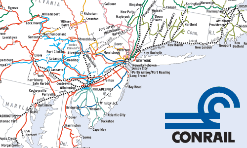
This map has been almost 25 years in coming. As soon as Conrail was formed in 1976, Trains readers began requesting a huge “breakdown” map of Conrail coded to predecessor railroads. The project was too big for the limited resources then available to us.
Thanks to Curt Richards, though, we now have a good source map for Conrail, and the fold-out format allows a larger map with greater detail. Curt took an official Conrail map of October 1980 and color-coded it. He also went one step back in merger chronology by differentiating lines originating with the Pennsylvania from the New York Central and New Haven lines, and former Erie from Delaware, Lackawanna & Western.
According to AAR statistics, on December 31, 1980, Conrail operated 18,902 route-miles, or 10.58% of the 178,629 U.S. Class 1 mileage. Even in 1980, remember, there were still 35 Class 1’s, from 27,361-mile Burlington Northern (including its newly acquired Frisco) down to 201-mile Elgin, Joliet & Eastern.
At this time CR was comprised of about 5300 former NYC miles, 4700 of the Pennsy, 1600 of ex-Erie Lackawanna (1100 Erie, 600 DL&W), 1000 of Reading, and lesser amounts of New Haven, Lehigh Valley, Jersey Central, Pennsylvania-Reading Seashore Lines, and Lehigh & Hudson River. Excluded are CR trackage rights over Amtrak, state-owned commuter lines, and freight lines such as Canadian National, B&O, C&O, L&N, and Norfolk & Western.
The traffic density of this Confrail system is depicted in the first installment of Fred Frailey’s “Conrail from the Inside Out,” in January 1981 Trains. Photocopies of old stories are available from our Customer Service Department for a modest charge.
Railroads included in this map:
Central of New Jersey; Central Indiana; Delaware, Lackawanna & Western; Erie; Lehigh & Hudson River; Lehigh Valley; New York Central; New York, New Haven & Hartford; Pennsylvania; Pennsylvania-Reading Seashore Lines; Reading


I appreciate the map, but if your proofreading is a sign, the map is probably wrong also. 1100 Erie-600 DL&W = 1700 Confrail?????????